Copyright by the editor, Hal Morris, Secaucus, NJ 1997. Permission is granted to copy, but not for sale, nor in multiple copies, except by permission.
Jacksonian Miscellanies is a weekly* email newsletter presenting short** documents from the United States' Jacksonian Era, which you can receive it for free by sending to hal@panix.com a message with
subscribe jmisc
as either the subject line, or as the *only* line in the message body. If you want to make a comment or query, please send a separate message to hal@panix.com.
((* Biweekly in the summer
** Typically 10-20 pages of printed text))
Jacksonian Miscellanies can also be read at http://www.panix.com/~hal/jmisc. The WWW version is augmented with much biographical, bibliographical, and other information.
Please direct responses and comments to hal@panix.com,
by Charles Haswell (NY: Harper, 1896)
BEEKMAN HOUSE, 1776, FIFTIETH STREET, NEAR FIRST AVENUE
THEY to whom memories and traditions of the city of New
York are known and dear, who love her fame and place, the noble setting
of her familiar scenery, and the very stones of her streets, have long
deplored the lack of civic pride among her inhabitants. Smaller cities
of the New World have wisely cherished their inheritance from a fruitful
past and communicated it to successive generations. The stories of the
"Boston Tea Party" and the "Boston Massacre," for example,
have been spread so widely by persistent and most proper efforts of the
Bostonians, as to become part of almost universal knowledge. The night
adventure of the pseudoIndians is known, and Crispus Attucks*
has become a child's hero. It would be matter for surprise, however, were
the average NewYorker, born and bred, to discover acquaintance with
the "New York Tea Party," which, without the cover of night or
Indian disguise, sent one of the laden teaships out of our harbor
back to England, and upset the cargo of another into the waters of the
bay; or had he so much as heard of the battle of Golden Hill**
wherein the first blood of the Revolution was spilt, two months earlier
than the "Boston Massacre," and more than five years before the
Lexington affair. I have no controversy with our sister cities who have
thus acted wiser than we, and am not jealous of their fame; on the contrary,
I commend them for example of life and instruction of manners.
* A halfIndian or mulatto, killed in the affray on
the 5th of March, 1770, known as the " Boston Massacre."
He was charged with being a leader in the riot, and his body was borne
by the surviving participants to it, and buried in the public burialground
with the other victims.
** The high ground between Cliff and Gold streets near John. In January, 1770, some British soldiers sawed down a Libertypole which the "Liberty Boys" had erected in celebration of the repeal of the Stamp Act. This action involved frequent and almost daily conflicts between the "boys" and the soldiers; and in a conflict soon after the soldiers were worsted, and the affair was from that time known as the battle of Golden Hill, where was shed the first blood of the Revolution that followed. Memory of the Gouden Bergh, as the Dutch called it, survives in the name Gold Street. Cliff Street perpetuates the name of Dirk Van der Cliff, and John Street that of another ancient worthy, John Harpendingh, who gave to the Dutch congregation the ground for their North Church.
Not to be jealous of the historic property of neighbor cities is no exalted virtue in a NewYorker, since the romantic and glorious history of his own town should suffice him. Twice has it been in Dutch occupancy; twice, or even thrice, under the British (if we count their return after the brief possession by the revolted Colonies); it was the scene, a hundred and sixty years since, of the first victorious fight for liberty of the press; the birthplace of the "Sons of Liberty," organized ten years before the Revolution to resist the Stamp Act; and in the same year the meetingplace of the American Congress (of nine Colonies), with its Bill of Rights, asserting the sole power of the Colonies to tax themselves. And then, the more than seven years' famine and blight, the wreck under occupation by the enemy during almost the whole Revolutionary period, the city's commerce gone, population decreased more than onehalf, onequarter of the houses burned, and many of the remainder-seized for barracks, hospitals, and prisons -- fallen into decay.
No other American city knew a tithe of such distress for country's sake, or gathered into its annals such store of various memories meanwhile- tragical, humorous, pathetic, romantic-as fills the pages of New York's history for those stirring years; battles over the ground where her new quarters are now rising; retreats, captures, evasions, daring personal exploits, horrors of prisonships, and every kind of moving incident, from Howe's unlucky delay over Mrs. Murray's Madeira[1] to the tragedy of Nathan Hale. And even now the city's soil is sown with relics of blockhouses and Revolutionary earthworks as reminders of some of these things.
Then came British evacuation and Washington's triumphal entry, followed almost at once by New York's astonishing revival, and opening of her famous career of prosperity and precedency. Soon afterwards followed Washington's inauguration and residence in New York, with the beginnings of the new government in the midst of the rising city. Surely there is no need for us to envy our neighbors such tales as they may claim and own of "the great days of old."
Of New York's indifference to her own historic treasures, it has been often said that she is too big and busy to care for such things; and a narrow mind, vaunting itself nevertheless as large and superior, has sometimes added that these matters are proper aliment only for the provincial spirit in smaller towns, where people have little other employment or cause for activity than to dwell on the past, and where the days are long. Happily, the propriety of this largesounding but small-minded declaration is beginning more generally to be doubted; more and more people are discerning the truth that a fond attachment to one's city is not an unmetropolitan quality; and though New York is larger and busier now than ever. it is in these latter days that indications abound and multiply of a rebirth among us of civic pride.
Perhaps this is largely due to the spirit engendered by our modern societies, organized (and much to be praised for their design) to perpetuate remembrance of "old, unhappy, faroff things, and battles long ago"-the Society of the Colonial Wars, the "Sons and the Daughters of the Revolution," "of the American Revolution," etc., etc. These, although they are not devoted to New York, must yet of necessity pay great tribute to her history. To them, or some of them, and to the feelings they inspire, are due the tablets marking many historic spots within our borders; the care to preserve unspoiled memorable sites and other objects; the fine statue of Nathan Hale in the City Hall Park, holding out perpetually to the throng of passers the graven inscription of his last regret -- that he had but one life to give for his country. Something of Hale's spirit (we hope it may not seem fantastic to say) appears to be passing, however feebly or slowly, into the blood of NewYorkers. Again they are caring for their city, as did their forefathers, with a nourished pride, not merely in her growth, her luxury and splendors, her unexampled financial credit and marvellous reach of business transactions, but also in her history and traditions.
To forward this good work is the main purpose of this volume, wherein some of the earlier recollections of eighty years are set down, while yet time and strength serve for that purpose. My hope is thus to fix some portions of the general history of New York in "the immortality of print," thereby to enliven the growing interest in the past of our beloved city, to increase attachment to her fortunes, inspire reverence for her great citizens, their good deeds and high achievements, her memories and monuments; and so in some degree to heighten that just pride in citizenship, which is perhaps the mainspring of patriotism. The changes, physical and social, that occurred in New York during the period amounting to more than the life of a generation, which, in these pages, is to come under review; in its topography, commerce, manufactures, in the customs, modes of life and intercourse of its inhabitants, were so great and varied that the instance of friends cognizant of the opportunities I have enjoyed to observe these mutations, further prompts me to essay a recital of such changes and a relation of incidents that have fallen under my observation, supported either by a distinct recollection or by reference for verification and dates to the daily records of the period.
I arrest the work at the close of 1860, because that date ends the period "before the war," after which more modern conditions prevailed, and it is unnecessary to remind a large portion of our citizens of customs and occurrences subsequent to that date. Notes and relations similar to these, but of more recent date, will unquestionably be supplied from other hands in the future, and I confine myself herein to that which, in point of time, may by the general public fairly be termed history. I have held rather closely to dates, as they appear in my notebooks, somewhat to the detriment of literary form, but on the whole concluding that order to be a needful clue for myself and my readers to follow through the wilderness of years. Gladly would I avoid the frequent appearance of the pronoun of the first person singular, but the use of it is a high convenience; the first person plural employed throughout a volume such as this sounds pretentious and absurd, besides causing a want of directness in communication between writer and reader, while the constraint of socalled impersonal verbs, or of the periphrastic manner in such phrases as "the author," "the present writer," " the observer," is held to be intolerable.
Readers of the present day may imagine for themselves the conditions of New York in 1816, on considering the fact that at that date the limits of the city as indicated by its dwellings, with the exception of a cluster of houses, etc., at the locations known as Harlem (One Hundred and Tenth to One Hundred and Thirtysixth Street); Greenwich Village (Perry to Horatio Street, and Bleecker Street to the river); Bloomingdale, or Harsenville (on Broadway, from Sixtysixth to Seventy third Street); Manhattanville (about Manhattan Street); Yorkville (in the vicinity of Eightysixth Street and Third Avenue); and "Manhattan Island," as it was termed (a part of the mainland being intersected by a marsh in the vicinity of the shipyards on the East River, from Rivington to Tenth Street), were clearly defined to be below Canal Street on the west, and irregularly below Prince and Rivington streets on the east side; its population being 93,634, and very few of its citizens enjoying the luxury of maintaining their own carriages.
In addition to increase in width by the establishment of an extended exterior or bulkhead line and the filling out thereto, the topography of the original area has been materially changed. Thus the many slips or basins on the river's front for the accommodation of vessels, as Rivington, Delancey, Broome, Grand, Pike, Market, Roosevelt, Peck, Burling, Maiden Lane, Coffee House (so named from the Tontine Coffee House at its head, on the corner of Wall and Water streets), Old, Coenties, and Whitehall slips on the east, and Albany Basin and Washington Market Slips on the North River, are all now filled in and closed, and the only evidence of their former existence is in the width of the streets immediately at the river front, notably as at Maiden Lane and Wall Street. The construction of bulkheads or piers above Barclay Street on the North River, and Market Street on the East River, was very incomplete at this time, the primitive shore being yet exposed in many places.
While referring to piers and slips it may not be amiss to add that, although we have a Dock Department and all the variations of dockbuilders, dockhouses, dockmen etc., there is not a dock in or on the island of New York; there are three in Brooklyn, and not to exceed ten in the United States. What are termed docks here are piers and bulkheads, constituting a wharf.
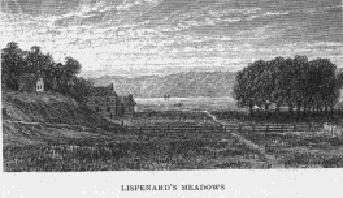 Lispenard's
Meadows, originally extending from Duane Street on the south to Broome
Street on the north bounded on the east by Broadway and on the west by
the North River, were but partly filled in (see page 16), and Canal Street
was then in process of grading, being crossed at Broadway over a bridge
of masonry universally known as the
Lispenard's
Meadows, originally extending from Duane Street on the south to Broome
Street on the north bounded on the east by Broadway and on the west by
the North River, were but partly filled in (see page 16), and Canal Street
was then in process of grading, being crossed at Broadway over a bridge
of masonry universally known as the
 "Stone
Bridge"; a publichouse on Broadway, near Walker Street, being
known as the Stone Bridge Hotel. ExMayor Daniel F. Tiemann writes
me that he has often skated under this bridge.
"Stone
Bridge"; a publichouse on Broadway, near Walker Street, being
known as the Stone Bridge Hotel. ExMayor Daniel F. Tiemann writes
me that he has often skated under this bridge.
As late as 1820 I, in company with an elder relative occasionally practiced pistolshooting at a target on a fence on the south side in this open and unfrequented street, between Broadway and Mercer Street.
The entire island was reticulated with a number of roads and lanes, notably the Boston Turnpike, beginning at Twentythird Street and Broadway, running through the present Madison Square Park, and irregularly across Third Avenue at Fortyfifth Street, east to Second Avenue, west to Sixtysixth Street, and then irregularly up the line of Third Avenue, nearly over to Fourth Avenue, and thence to Harlem Bridge, at Third Avenue and One Hundred and Thirtieth Street.
Of roads: the Middle Road, from Boston Turnpike at Twenty-eighth Street and Fourth Avenue at Twentyninth Street, and Madison Avenue between Thirtyfifth and Thirtysixth streets, then running direct to Fifth Avenue at Fortysecond Street.
The old Kingsbridge Road, from Eighth Avenue at the termination of Harlem Lane (St. Nicholas Avenue), to road at One Hundred and Twentyfifth Street; Kingsbridge, a continuation of Broadway, or turnpike to Albany and intermediate towns.
The Abingdon, or "Love Lane," as it was generally termed, from Eighth Avenue between Twentyfirst and Twenty-second streets to Broadway at Twentyfirst Street, thence to Twentythird Street, and to Third Avenue.
The Hell Gate, from Boston Turnpike, between Eighty-fourth and Eightyfifth streets, to Second Avenue and Eightysixth Street, thence to Eightyseventh Street between First and Second avenues, thence to foot of Eightysixth Street, at East River.
The Skinner (Christopher Street), to Union, between Fifth and Sixth avenues, Eleventh and Twelfth streets.
The Southampton, from Eighth Avenue near Fourteenth Street, northeast to Nineteenth Street, and between Fifth and Sixth avenues, thence northerly to Abingdon Road, north of Twentyfirst Street, east of Sixth Avenue.
The Fitzroy, from Southampton, commencing at Fourteenth Street, between Seventh and Eighth avenues, to centre of block between Nineteenth and Twentieth streets, thence across Eighth Avenue between Twenty-second and Twentythird streets to Thirtieth, thence through Eighth Avenue to between Thirtyfirst and Thirtysecond streets, thence northwesterly to between Fortyfirst and Fortysecond streets, reaching Forty-second Street between Eighth and Ninth avenues. Harlem, from between Third and Lexington avenues and One Hundred and Twentieth and One Hundred and Twentyfirst streets, to One Hundred and Twenty-fourth Street and Fourth Avenue, to One Hundred and Twentyseventh Street between Sixth and Seventh avenues, thence to St. Nicholas Avenue between One Hundred and Thirtyfirst and One Hundred and Thirty-second streets.
The Old Kill Road (Gansevoort Street).
The Lake Tour Road, from Thirtyninth Street and Bloomingdale Road to Seventh Avenue, thence to Ninth Avenue between Fortysecond and Fortythird streets.
The Union, from Skinner Road, Eleventh and Twelfth streets and Fifth and Sixth avenues, to the Southampton at Fifteenth Street and Seventh Avenue.
Of lesser roads there were: the Great Kill, running from the intersection of Ninth Avenue and Greenwich Street at the North River, directly across the island to Fitzroy Road between Seventh and Eighth avenues, thence to Sixth Avenue between Fifteenth and Sixteenth streets, thence to " Love Lane " between Fifth and Sixth avenues at Twentyfirst Street.
The Warren, from Southampton to Abingdon Road, or from Sixteenth between Sixth and Seventh avenues to Twentyfirst Street.
The Harsen, from Sixth Avenue between Seventieth and Seventyfirst streets to Ninth Avenue, thence to Bloomingdale Road (Broadway) at Seventy-first and Seventysecond streets.
Of Lanes there were: the Minetta, Eighth Avenue and Fourteenth Street between Seventh and Eighth avenues to Fortysecond Street.
The Low, from Boston Turnpike at Fortyfirst Street to Seventh Avenue at Fortyfourth Street. The Jauncey, from Bloomingdale Road at Ninety-third Street west to Sixth Avenue. The Harlem (St.Nicholas Avenue), from One Hundred and Tenth Street and Sixth Avenue to near One Hundred and Twentyfourth Street.
The Monument (Obelisk Lane), Greenwich Lane from Bowery Road to Minetta Creek, and thence to intersection of Eighth Avenue and Thirteenth Street, where an obelisk was erected to Majorgeneral Wolfe.
The Amity, from Broadway to Thompson Street, between Bleecker and West Third streets.
The Rhinelander,from Second Avenue between Eightysixth and Eightyseventh streets, to Ninetieth Street between First Avenue and Avenue A.
The Feitner, from Broadway between Fortyfifth and Fortysixth streets, crossing Eighth Avenue at Fortysixth Street, and Ninth Avenue between Fortyseventh and Forty-eighth streets, thence to Fortyninth and Fiftieth streets between Tenth and Eleventh avenues.
The Hopper, from Fiftieth Street and Sixth to Seventh avenues, to Broadway between Fiftieth and Fiftyfirst streets, to Twelfth Avenue and Fiftythird Street. The Greenwich, from Eighth Avenue and Great Kill Road, Bowery and Stuyvesant Street.
The Rose Hill, from Eighth Avenue between Twentyfirst and Twenty-second streets to Broadway, to Twentythird Street and Third Avenue.
The Verdant, from Bloomingdale Road between Fortyfifth and Fortysixth streets to Tenth Avenue between Fortyeighth and Fortyninth streets, thence to Twelfth Avenue; --
and in addition to these there were many private lanes leading from country residences and farms to the main roads.
McGowan's Pass was on the Old Kingsbridge Road east of Sixth Avenue and north of One Hundred and Eighth Street; and Breakneck Hill rose from Kingsbridge Road to the line of Ninth Avenue between One Hundred and Fortythird and Fortyfourth Streets; South Street ended at Dover, and Front at Roosevelt Street.
At the foot of Thirtyfifth Street on the North River was a glass furnace, and the prominence of the shore at that point was termed the Glass House Point.
It may be of interest to some to learn why the blocks located by the Commissioners in 1807 above First Street on the east side and Thirteenth Street on the west side are so irregular in their widths, and why the wide streets are so irregularly spaced, as Fourteenth, Twenty-third, etc., some of the blocks varying from 181 feet 9 in. to 211 feet 11 in., and not one being of 200 feet; and inasmuch as the surveyor, Mr. John Randall, Jr., so personally advised me, I am authorized to state it, thus: In running the line of the central avenue he defined certain divisions of the work by his rough or preliminary measurements, and instead of changing these points, as he progressed with his final survey, to the sum of a given number of blocks of 200 feet, streets of 60 feet and one of 100 feet in width, making 10 streets (with one wide one) exactly half a mile, he divided the distance between his assumed or trial points by the number of blocks, streets, avenues, and wide streets, approximating the distance between the points; and as this distance was fractional, and the width of the streets and avenues fixed, the quotient was the width of the blocks between each of the trial points; and as a result of such a proceeding they were fractional.
The iron railing around the Bowling Green was imported from England in 1771; it is standing at this time (1895).
At the time here under mention the principal fronts of the blocks on Broadway, on the west side between Franklin and White streets, and on the east side between White and Walker streets, were in primitive soil, and enclosed with board fences.
Many of the older streets still retained names now forgotten. The craze for a change, so familiar to NewYorkers of modern date in their loss, for example, of Amity, Anthony, Bancker, Chatham, and Robinson streets (to name only the first that come to mind), has swept away ancient designations that they know not of. Thus, in earlier times, South William Street was known as " Dirty Lane"; Cliff, as "Elbow Street"; Nassau, originally as "Pie Woman's Lane"; Beaver, as "Slaughterhouse Lane"; Broad, as "Smell Street"; Elm, as "Republican Alley"; Washington Place, from University Place to Fifth Avenue, as "Shinbone Alley."
Hanover Street was Slote Lane; Exchange Place was Garden Street from Hanover to Broad, and thence to Broadway was called "Flat and Barrack Hill," this descent being then a favorite place of boys for "coasting."
The narrow passage nearly opposite-from the west side of Broadway to Trinity Place (Church Street)-was colloquially, if not legally, termed "Tin Pot Alley," the title it bears to the present day, though some absurd person of more or less authority has endeavored to effect a change by putting on an adjacent streetlamp the name "Exchange Alley," to denote a passage wherein less exchange takes place than in any other throughout the entire city. We have noted with singular pleasure that when demolition and rebuilding were in progress in this locality that stanch NewYorker, the Rev. Dr. Morgan Dix, desiring to make sure the perpetuation of a time-honored name, prepared, at his own care and cost, a decorated tablet of graceful design, bearing the old name, which was built into the wall of the new structure on the south corner. A tailor's impudent sign has been suffered to cover; full onehalf of this tablet, and has so far been permitted to defeat Dr. Dix's I laudable purpose. It may be hoped that the tailor's sense of his trade interest with old NewYorkers may induce him to place this sign a little lower.
In the lower part of the city, in Broad Street, there
were remaining a number of Dutchdesigned and Dutch-built houses, 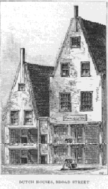 with their gableends to the street, and sharply pitched
roofs, with stoops at their front doors. As the definition
of this word is often asked, I give it thus: Stoepen, also een
stoep bancke, a seat or bank before a house.
with their gableends to the street, and sharply pitched
roofs, with stoops at their front doors. As the definition
of this word is often asked, I give it thus: Stoepen, also een
stoep bancke, a seat or bank before a house.
The aristocratic quarter for residences at this period was Whitehall, Beaver, Broad, Water, and Pearl streets, and the lower part of Broadway. Cherry, Roosevelt, Oak, Madison, Oliver, Harman (East Broadway), and Market streets were occupied by many people of position and fortune.
Not only the detached clusters of buildings abovenamed,
as Harlem, Yorkville, etc., but also
 Kip's
Bay, at Thirtysixth Street, and
Kip's
Bay, at Thirtysixth Street, and
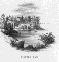 Turtle
Bay, at Fortysixth Street, on the east side; with Stryker's Bay, at
Ninetyfifth and Ninetysixth streets, on the west side, were at
this date positive and recognized localities.
Turtle
Bay, at Fortysixth Street, on the east side; with Stryker's Bay, at
Ninetyfifth and Ninetysixth streets, on the west side, were at
this date positive and recognized localities.
Madison Square was a pasture. Tompkins Square, with the area to east of it, was a swamp. At the intersection of Grand Street and East Broadway (Herman Street) was the hill known as Mount Pitt. Broadway above Tenth Street was a country road.
The Collect- that is, the pond that had been bounded by White, Bayard, Elm, Canal, and Pearl streets, which naturally had discharged into the East River through "Wreck Brook," across the region still known as "The Swamp," but had been diverted into the North River through a drain cut on the line of Canal Street, passing under the Stone Bridge-was but partly filled in.
Many primeval streams and water courses existed upon this island of Manhattan. Most of them have been filled up, and their flow checked and diverted; but though not apparent now, they still exist, and except for the area covered by buildings and pavements, with the artificial leadingoff of rain and snowwater, would appear in their original force.
In this year Minetta stream was fully apparent; and as it was and is of considerable volume, it has been a very important and expensive factor in the construction of foundations along its line, from its main source, near the site of the Union Club, to its discharge in the North River. Its other branch had its source at Sixth Avenue and Sixteenth Street, the two joining between Eleventh and Twelfth streets and Fifth and Sixth avenues; its course thence being irregular to Minetta Lane and Bleecker Street, thence direct to Hudson Street at King Street; then bifurcating and joining at Greenwich Street, thence to the river by Charlton Street.
Sunfish and Stuyvesant's ponds were in their original outlines, the former bounded by Thirtyfirst and Thirty-third streets and Madison and Lexington avenues, fed by a stream rising between Sixth and Seventh avenues at Fortyfourth Street, and flowing into the East River between Thirtythird and Thirtyfourth streets; the latter lying between Second Avenue, Thirteenth and Fourteenth streets and the East River, with Stuyvesant's Swamp adjacent, an extensive area of low alluvial land receiving water from several tributary streams. Stuyvesant's Meadows was the basin of a stream rising between Fourteenth and Fifteenth streets at Second Avenue, running irregularly to Nineteenth Street and First Avenue, and discharging into the East River between Fifteenth and Sixteenth streets. In winter the greater portion of them was covered with water, and, forming a large pond, was a favorite resort for skating, as was Sunfish Pond also. The gluefactory of Peter Cooper adjoined Sunfish Pond, he having previously occupied the triangular plot formed by the intersection of Third and Fourth avenues as a store.
At Seventeenth Street and the East River was an indentation of the shore, into which emptied a stream rising west of Madison Square, and flowing north of Gramercy Park. Sawmill Creek rose between Fortyninth and Fiftieth streets, west of Sixth Avenue, and ran north to Fifty ninth Street, turning then southwest of the East River at Fortysixth Street.
Above this were several streams on both sides of the island, notably the Harlem Creek, rising in the vicinity of One Hundred and Twentythird Street and Tenth Avenue, and flowing directly to Fifth Avenue at One Hundred and Sixteenth Street, thence to One Hundred and Sixth Street, thence to East River, between One Hundred and Seventh and One Hundred and Eighth streets.
Canal Street: when this great thoroughfare was filled in, it became necessary to continue the original stream or water course through it in a sewer, which led from Centre Street to the river; and whenever it became necessary to clean its bottom, prisoners from Bellevue were employed, the vicious being restricted by an iron ball and chain secured to one or both of their legs.
Lispenard's Meadows, as well as the site of Tompkins Square, were good snipe grounds; while the various suitable places above them, notably the site of Central Park and the low ground between it and the East River, furnished ample extent for an entire day's shooting; and Twentysixth to Thirtieth, Thirtyninth to Fortythird, Sixtyfourth to Sixtysixth, Seventyninth to Eightyfifth, and Ninetysixth streets, on the west side, of which I was cognizant, were good for both woodcock and snipe. I have shot woodcock in West Twentyfirst Street and Tenth Avenue, and rabbits between Cato's Road and Third Avenue; while Fourteenth Street was generally the limit of my shootinggrounds on Saturday holidays.
What is now known as Brooklyn Heights was at this time a high and precipitous sandhill, with a stairway leading to its summit, on which were three houses, one a hotel, one a boardinghouse, and one the residence of a Mr. Gibbs, who brought from his former residence in North Carolina a cutting of a grapevine, which he planted in the grounds of his new residence and named Isabella, after his daughter of that name, and hence the "Isabella grape" of the subsequent and present time.
Still Hook and Pierrepont's windmill were opposite to Governor's Island, near to Atlantic Street.
Red Hook was a promontory on the Brooklyn shore at Van Dyne Street, and Yellow Hook, on which was a powderhouse on the same shore, was at the southern point of Gowanus Bay, all of which, alike to Turtle and Kip's bays on the East and Stryker's Bay on the North River, have been obliterated by the extension of the river fronts.
Gowanus Bay was very shallow and prolific with clams. At low water men were seen "treading" for them; hence the wellknown truism, "One should never go clamming at high water."
The North River above Barclay Street was not fully bulkheaded, and on it but eight piers existed; the point of Corlear's Hook, East River, was an open shore, resorted to by the Baptists for practice of the rite of immersion, and all above North (Houston) Street was a primitive shore.
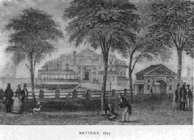 The Battery, sed quantum mutatus ab illo was the sea breathingspot,
and, in proportion to the number of citizens, it was much more frequented
than Central Park is at the present period of 1895. It was bounded seaward
by a riprap wall between it and Fort Clinton, now Castle Garden, and
very far inside of the present extension. A bridge about two hundred feet
in length connected the shore and the fort. The area of the Battery was
extended and walled in at a later period (about 1823), and again extended
and walled in in 1856. It was the afternoon resort of children, and in
summer the evening resort and promenade of citizens. Ladies could visit
it with impunity, even when unaccompanied by a gentleman.
The Battery, sed quantum mutatus ab illo was the sea breathingspot,
and, in proportion to the number of citizens, it was much more frequented
than Central Park is at the present period of 1895. It was bounded seaward
by a riprap wall between it and Fort Clinton, now Castle Garden, and
very far inside of the present extension. A bridge about two hundred feet
in length connected the shore and the fort. The area of the Battery was
extended and walled in at a later period (about 1823), and again extended
and walled in in 1856. It was the afternoon resort of children, and in
summer the evening resort and promenade of citizens. Ladies could visit
it with impunity, even when unaccompanied by a gentleman.
Castle Garden has an interesting history; erected in 1814, and first named Fort Clinton, the result of a massmeeting held in the City Hall to consider the best means of fortifying the city should the war with England extend northward. During its construction a patriotic dame of high social position trundled a wheelbarrowful of earth from Trinity Churchyard down Broadway to the fort.
When the property was ceded back to the city by the Federal Government in 1822, in consequence of the removal of military headquarters to Governor's Island, it was determined to convert Fort Clinton (or Castle Clinton) into a place of public amusement, and as such, under the now familiar name of Castle Garden, it long fulfilled its purpose admirably, and is well remembered as the home of the opera and the scene of Jenny Lind's extraordinary triumphs. Philip Hone's Diary describes it as "the most splendid and largest theatre I ever saw-a place capable of seating comfortably six or eight thousand persons. The pit or area of the pavilion is provided with some hundred small, white tables and movable chairs, by which people are enabled to congregate into little squads, and take their ices between the acts. In front of the stage is a beautiful fountain, which plays when the performers do not. The whole of this large area is surmounted by circular benches above and below, from every point of which the view is enchanting."
But in spite of the charms set forth in this glowing account,
the drift of society uptown made Castle Garden impracticable as a place
of evening amusement after a while. It fell into sordid uses as a lodgingplace
for arriving immigrants, and so continued for a long space. Now, after
a long and needful process of cleansing, does it return to its function
of amusement- fitly and conveniently chosen, as it is, for the location
of the Public Aquarium.
On the east side of Greenwich Street, near the Battery, was the Atlantic Garden, a wellconducted and popular resort of the time (see p. 60).
In line with the foot of Hubert Street, a waterfort stood some two hundred feet out in the river, approached by a bridge, which, like the Battery, was a favorite resort for the dwellers of the vicinity on summer evenings. This fort, built of freestone, was known as the
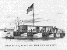 "Red Fort," while one at the foot of Gansevoort Street, being
whitewashed, was called the "White Fort."
"Red Fort," while one at the foot of Gansevoort Street, being
whitewashed, was called the "White Fort."
The Spingler estate, on Broadway, from Fourteenth to Sixteenth Street, to below Union Square, was at this time a marketgarden. Originally it consisted of twenty-two acres, and was purchased by Henry Spingler in 1788 for less than five thousand dollars.
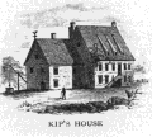
The Murray House, from which Murray Hill gains its title, and which remained standing until it was burned in 1834, was on a farm between the Bloomingdale Road (Broadway) and the Boston Post Road, and running down to Kip's Bay (East Thirtythird and Thirtyseventh streets).
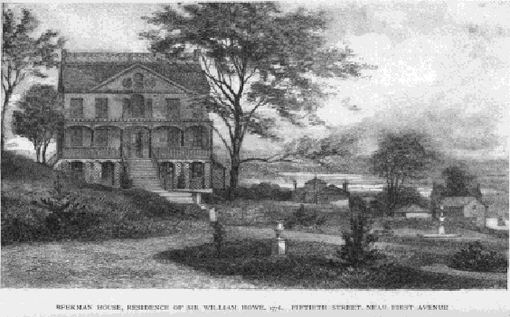
The Beekman House, which stood till twenty years ago on Fiftyfirst
Street near Second Avenue, was built in 1763 by a descendant of William
Beekman, who came from Holland with Petrus Stuyvesant in 1647. Headquarters
of Sir William Howe and General Charles Clinton during the war of the Revolution,
it witnessed many scenes of historic interest. It was in this house that
Major Andre stayed the night before he proceeded on his fatal adventure;
and, by a striking coincidence, it was here that Nathan Hale had been brought
for examination after his capture, and here received (tradition says in
the greenhouse) such trial or hearing as was allowed him. We may wonder
if the thought of Hale visited Andre on his last night of peaceful rest
in this place, haunted by memories of his prototype.
The pulling down of the Beekman House in 1874 was observed with keen regret. One of its fireplaces was presented by Mr. James W. Beekman to the New York Historical Society, in whose keeping it may be seen.
On Broadway, on the Grand Boulevard, bounded on the north by Jauncey Lane (Ninetyfirst and Ninetysecond streets), was the Apthorpe Mansion of an earlier period, and later the residence of Colonel Thorne, formerly a purser in the Navy, who married Miss Jauncey; the boundaries of this property included many acres (see p. 258). The place, for years before its disappearance in 1892, was occupied for the entertainment of targetexcursions, as a beergarden, etc., known as Elm Park.
On Cherry Street, between Clinton and Jefferson streets, was the home of Colonel Rutgers, which, after his death, was remodelled by his nephew, the late Wm. B. Crosby.
Colonel Marinus Willett resided upon his farm, extending from Broome to Delancey Street, and from Lewis Street to the river.
On Water Street, between Walnut (Jackson) and Scammel streets, was the residence of Christian Bergh, the father of the late Henry Bergh; and between the street and the river was his extensive shipyard-established in this year.
West of Broadway, between Eleventh and Twelfth avenues,
at One Hundred and Twentythird Street, there was a large country residence
occupied by an Englishman a Mr. Courtney, who, with but one manservant
and a cook, lived so retired as never to be seen in company with any one
outside of his household, and very rarely in public. There were, as a consequence.
many opinions given as to the occasion of such exclusiveness. The one generally
and finally accepted was that he had been a gay companion of royalty in
his youth, and that his leaving England was more the result of expediency
with him than choice. The house subsequently was known as "The Claremont"
(see p. 377).
The State's Prison building and ground occupied about four acres in Washington, bounded by Christopher, Perry, and West streets, surrounded by a high stone wall, guarded by sentries. An extensive brewery now occupies the site of this building (see p. 226).
The City Prison, or Bridewell, stood on Broadway in line
with the present
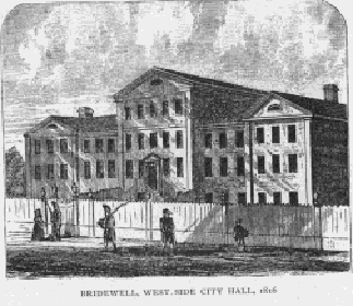 City
Hall, and the Jail, or Debtors' Prison, alike in line with it at its opposite
end, where it still stands, converted into the
City
Hall, and the Jail, or Debtors' Prison, alike in line with it at its opposite
end, where it still stands, converted into the
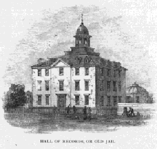 Hall
of Records, the veritable though altered structure of the old jail changed
into a really beautiful form, though now bearing an unsightly wooden top.
Between those buildings, where now is the new Court House, was the Almshouse
on Chambers Street.
Hall
of Records, the veritable though altered structure of the old jail changed
into a really beautiful form, though now bearing an unsightly wooden top.
Between those buildings, where now is the new Court House, was the Almshouse
on Chambers Street.
March I Hudson Street extended from Gansevoort Street to Ninth Avenue.
In May the Penitentiary adjoining the new Almshouse at Bellevue was first occupied, and the convicts therein were employed in the opening and improvement of contiguous roads and streets.
Dr. McLeod proceeded to Washington, organized the American Colonization Society, and wrote its Constitution.
The markets were the Fly (Vlie or Vly, an abbreviation of valley), located at the foot of Maiden Lane, which was this year ordered to be removed (see p. 141); the Washington, at foot of Vesey and Fulton streets, on the site of the Bear (1814), by which name the Washington was known for many years; the Catharine, at foot of the street of that name; the Old Slip, at foot of William Street, afterwards the Franklin; the Duane, at foot of the street so named; the Collect, on the south side of White Street, near Broadway and Cortlandt Alley (removed in 1818); the Greenwich, foot of Christopher Street; and the Gouverneur, foot of that street, erected at the individual cost of Christian Bergh, the shipbuilder in Water Street; and one at the foot of Grand Street.
The Grand Market Place, which embraced Tompkins Square, bounded on the north by Tenth Street, south by Seventh Street, east by the river, and west by Avenue A, was laid out in 1807 by three commissioners, Gouverneur Morris, Simon De Witt, and John Rutherfurd, but subsequently was abolished by an Act of the Legislature.
You can support this site at no cost if you make an Amazon purchase using this link to get to Amazon: Thanks